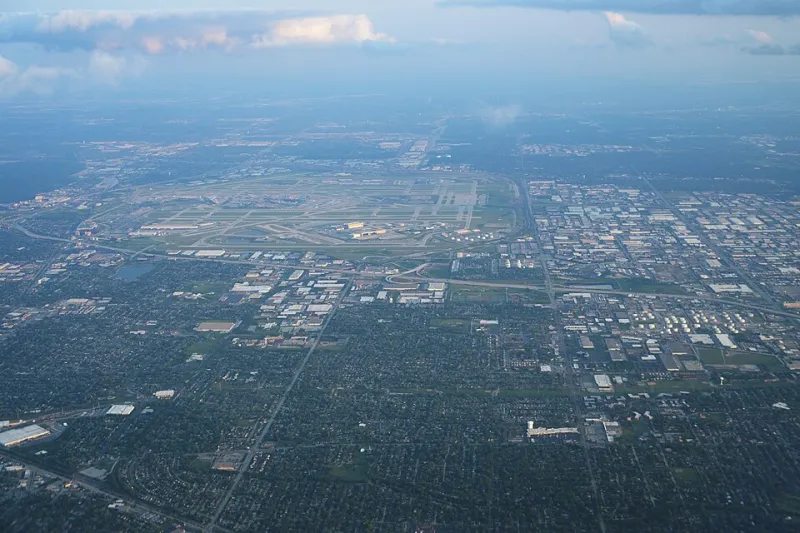
Open a map of almost any American city and you'll see it immediately: the grid. Straight lines crossing at right angles, blocks stacked in neat rows, streets running north-south and east-west with a regularity that feels almost mathematical. Chicago, Phoenix, Denver, Salt Lake City, Houston — the pattern repeats with minor variations across hundreds of cities and thousands of towns. It's so consistent that Americans rarely think about it. The grid just is the way cities look.
Except it isn't inevitable. It isn't natural. And it wasn't born from any grand vision of what American urban life should become. It was born from a paperwork crisis in 1785, and the men who created it had never set foot in most of the land they were dividing.
The Problem of All That Land
After the Revolutionary War ended, the newly formed United States found itself in possession of an enormous territorial windfall. The 1783 Treaty of Paris extended American sovereignty to the Mississippi River — a vast expanse of land that the new federal government urgently needed to do something with. The country was broke. The Continental Army needed to be paid. Settlers were already pushing westward without any legal framework to establish who owned what.
Congress needed to sell land, and to sell land, it needed to survey land. The problem was that the territory in question — what would eventually become Ohio, Indiana, Illinois, and beyond — was largely unmapped, frequently contested, and full of geographic features that nobody in Philadelphia had personally encountered. The government needed a system that could be applied quickly, consistently, and by surveyors working with incomplete information across an enormous area.
The solution came in the form of the Land Ordinance of 1785, passed by the Continental Congress on May 20th of that year.
The Compromise That Became a Blueprint
The ordinance established a system for dividing western territories into townships six miles square, each subdivided into 36 one-mile-square sections of 640 acres apiece. The geometry was simple by design. Squares were easy to measure, easy to describe in legal documents, and easy to subdivide further for sale. A surveyor could establish a baseline and a principal meridian, then project the grid outward across the landscape without needing to physically walk every inch of terrain.
This was the critical feature: the system worked on paper before it worked on the ground. Surveyors could calculate lot boundaries from a fixed reference point, record them in a land office, and sell parcels to buyers who might be hundreds of miles away. The grid was, at its core, an administrative convenience — a way to manage the complexity of mass land distribution without a proportional investment in physical survey work.
Thomas Jefferson was among the system's primary architects, and his influence shows. Jefferson had a deep intellectual attachment to geometric order, to the idea that rational systems could be imposed on the physical world to produce predictable, equitable outcomes. The township grid was Jeffersonian idealism expressed in surveying stakes.
What nobody fully anticipated was what would happen when people actually showed up to live on the land.
When the Grid Became the City
As American settlement pushed westward through the late 18th and 19th centuries, the township grid did something nobody had specifically planned for: it became the default layout for towns and cities. When a settlement grew large enough to need streets, the grid was already there as an organizing framework. Roads followed property lines. Blocks conformed to section boundaries. The geometry that had been established for land sale purposes became the geometry of urban life.
City planners — and in many cases, there were no professional planners involved, just land speculators and local officials making practical decisions — defaulted to the grid because it was already embedded in the landscape. It was the path of least resistance. You could lay out a new town in an afternoon if you were just extending the existing grid, naming the streets, and selling the lots.
The results were remarkably uniform. American cities built during the 19th and early 20th centuries share a family resemblance that has no real equivalent in Europe, where urban layouts evolved organically over centuries from medieval street patterns, river crossings, and defensive fortifications. American cities were, in many cases, designed before they existed — platted on paper, sold as lots, and then physically constructed to match the map.
The Standard Block and Its Consequences
The grid didn't just determine street orientation. It determined scale. The standard American city block — typically somewhere between 200 and 900 feet long depending on the city, with significant variation — emerged from the practical subdivisions of the original survey sections. That scale shaped everything: how far people walk between intersections, how buildings are sized and oriented, how utilities are routed, how neighborhoods feel at street level.
In cities like Portland, Oregon, where the original plat established unusually small blocks of about 200 feet, the result is a walking environment with frequent intersections and a fine-grained urban texture. In cities like Salt Lake City, where Brigham Young specified 660-foot blocks to allow ox teams to turn around, the scale is dramatically different — wider streets, longer walks between corners, a more spacious but less permeable urban fabric.
These weren't aesthetic choices, exactly. They were functional decisions made under specific historical circumstances that then calcified into permanent physical form. The city you live in today was shaped by what a surveyor or a land speculator thought was convenient in 1820 or 1850 or 1880.
Living Inside Someone Else's Workaround
There's something quietly remarkable about the fact that the physical experience of daily American life — the length of your commute, the shape of your neighborhood, how long it takes to walk to the corner — was determined in large part by a congressional efficiency measure designed to solve a land-sale paperwork problem.
The men who wrote the Land Ordinance of 1785 weren't urban planners. They weren't thinking about pedestrian experience or neighborhood character or the relationship between street width and community cohesion. They were thinking about how to divide and sell an enormous amount of land as fast as possible, with the administrative tools available to a cash-strapped new government.
The grid was their shortcut. It just happened to be a shortcut that hundreds of millions of people are still living inside.